Enregistrez gratuitement cette image
en 800 pixels pour usage maquette
(click droit, Enregistrer l'image sous...)
|
|
Réf : T01609
Thème :
Terre vue de l'espace - Villes (375 images)
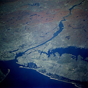
Titre : New York City and Lower Hudson River Valley, New York, U.S.A. October 1993
Description : (La description de cette image n'existe qu'en anglais)
New York City, the most populous city in the United States, is the focal point of this low-oblique, northwest-looking photograph. The entire waterfront of the lower Hudson River is lined with wharves, piers, and docks. This area is one of the major trade centers of the nation and, in particular, the major one serving the northeastern region of the United States. The body of water south of the mouth of the Hudson River is Lower New York Bay, and the slightly wider bay north of the mouth is Upper New York Bay. The Lower Bay is flanked by two peninsulas: Sandy Hook juts out from the New Jersey side, and Rockaway Point extends into the bay as an appendage of Long Island. The large amphitheater-shaped bay east of Rockaway Point is Jamaica Bay. John F. Kennedy International Airport is located on the northeast side of Jamaica Bay. The East River separates Long Island from Manhattan Island, one of five boroughs of New York City. The rectangular feature in the middle of Manhattan Island is Central Park. Toward the northwest third of this picture, a swath of hilly terrain mixed with numerous lakes trends southwest-northeast. This terrain is the result of the glacial scouring during the last ice age. It is evident by the red and brown coloring of the forest foliage that this photograph was taken in the fall.
|
|

